Date: 07 Nov 2022
Oasis Circular No.: 2210
Subject: MSA issued notices on route adjustment between Yantai and Weihai and alert of fishery farms to the south of the new route
I. Adjustment of the route between Yantai and Weihai
In order to ensure safe navigation, the route between Yantai port and Weihai port was adjusted on 10 Feb 2022 as there were some fishery farms around the previous route. The new route applies not only to vessels which navigate between Yanatai and Weihai ports but also to those which navigate between Chengshantou and Yantai port. Shandong MSA published a Notice for this adjustment on 10 Feb 2022 (ref: Lu Hang Tong〔2022〕No. 0059). Details of the new route are as follows:
Yantai port – Weihai port | The north boundary | The south boundary | Depth on chart (m) |
Longitude(E) | Latitude(N) | Longitude(E) | Latitude(N) |
Starting point | 121°33’24’’ | 37°40’30’’ | 121°33’36’’ | 37°38’30’’ | 17.3-23 |
End point | 121°59’42’’ | 37°41’36’’ | 122°06’36’’ | 37°40’00’’ |
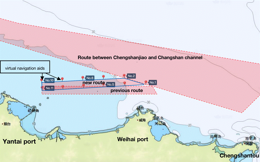
Furthermore, 11 virtual navigation aids have been set on both sides of the new route. The coordinate positions and MMSI numbers of the 11 virtual navigation aids are as follows:
Virtual Navigation Aid No. | Coordinate | MMSI No. |
No.1 | 37°40.00’N/122°06.60’E | 994126108 |
No.2 | 37°41.60’N/121°59.70’E | 994126109 |
No.3 | 37°39.71’N/121°59.85’E | 994126110 |
No.4 | 37°41.33’N/121°53.12’E | 994126111 |
No.5 | 37°39.42’N/121°53.31’E | 994126112 |
No.6 | 37°41.06’N/121°46.55’E | 994126113 |
No.7 | 37°39.12’N/121°46.74’E | 994126114 |
No.8 | 37°40.78’N/121°39.97’E | 994126115 |
No.9 | 37°38.81’N/121°40.17’E | 994126116 |
No.10 | 37°40.50’N/121°33.40’E | 994126117 |
No.11 | 37°38.50’N/121°33.60’E | 994126118 |
As illustrated below, the new route is located to the north of the previous one.

An illustration of the previous route and the new route
II. Fishery farms at the southern edge of the new route
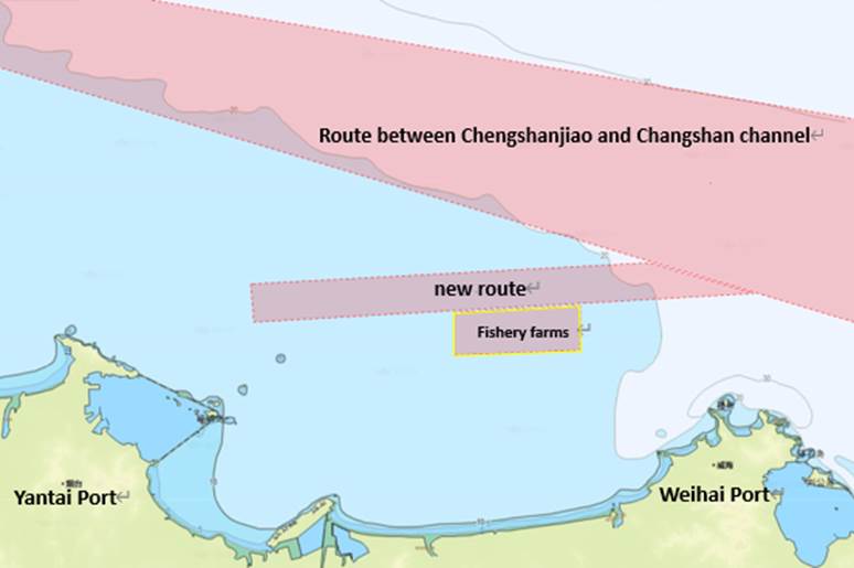
Shandong MSA further issued a notice on 06 July 2922, alerting that there are some fishery farms about 200m away from the southern edge of the new route. If a vessel navigates in the previous route, there is a high possibility that the vessel may enter into the fishery farms. It has been reported that this year some vessels which called Yantai port entered into these fishery farms when they were sailing in the previous route. According to the MSA notice, the fishery farms are mainly within the coordinates listed as follows:
A 37°38.99’N/ 121°46.83’E
B 37°39.35’N/ 121°55.17’E
C 37°37.02’N/ 121°55.17’E
D 37°36.75’N/ 121°46.83’E

An illustration of fishery farms at the southern edge of the new route
Suggestions on navigation safety
1. Vessels that call Yantai port are reminded to navigate in the new route.
2. Crew members are reminded to pay attention to the fishery farms at the edge of the new route and avoid deviation therefrom.
3. Crew members are suggested to maintain proper lookouts, keep nav-aids in good working condition and comply with the COLREG 1972 at all times.
4. When the vessel navigates in the route, pay attention to the water depth to avoid grounding.
5. The above is for reference only. Master is suggested to check with the local agent for the latest information if necessary.
We hope the above is of assistance. If there is any query, please feel free to contact us at oasis@oasispandi.com at any time.
Best regards,
Oasis P&I Services Company Limited
